


Boundary planning. Visualized. Simplified.
GeoSchool presents the district's data in an intuitive, interactive GIS interface, allowing users to visualize enrolment trends, explore boundary changes, and simulate “what-if” scenarios without the need for technical expertise.
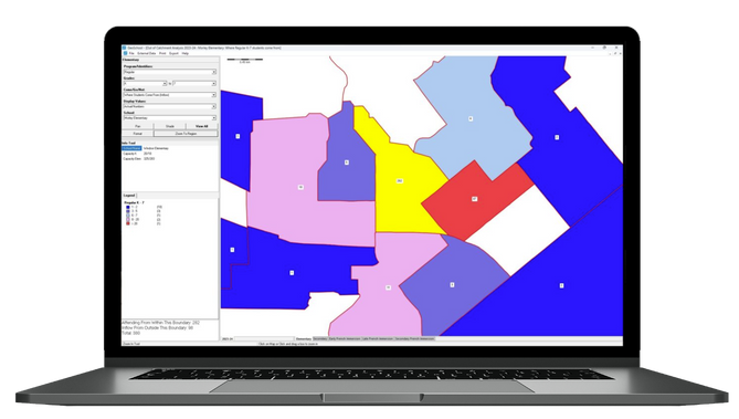
What GeoSchool Does
-
Visualize Data in an Easy-to-Use GIS Platform
Utilize built-in and custom filters to analyze student distribution by school, grade level, program, and more.
-
Analyze Cross-Boundary Movement
Instantly see how many students are attending their in-boundary school versus crossing into another catchment — providing clarity around utilization and enrolment pressure.
-
Model “What-If” Scenarios
Simulate boundary changes, school closures, or new school openings. GeoSchool automatically generates impact reports, helping districts assess how many students are affected and where they'd go.
-
Multi-Year Analysis
Access several years of historical data to understand how enrolment patterns have changed over time, and forecast how they may shift in the future.
-
Support Public Consultation
GeoSchool is frequently used in community meetings to transparently present proposed boundary changes and foster public understanding and engagement.


Why Districts Use GeoSchool
Whether you're responding to shifting demographics, managing growth, or optimizing underused facilities, GeoSchool gives you the power to act with clarity. It's easy to use, fully supported by Baragar’s team, and can be used alongside Demographic Dynamics for quick 'what if' checks on forecasting impact.
GeoSchool turns complex boundary data into confident planning decisions — helping school districts balance enrolment, minimize disruption, and build trust with their communities.
Benefits
Visualize Student Distribution
Instantly see where students attending your schools are coming from — for better planning at a glance.
Test Boundary Scenarios with Confidence
Model proposed boundary changes, school closures, or new school openings and see the real-time impact on enrolment, programs, and capacity.
Support Transparent Public Consultation
Use GeoSchool in public meetings to clearly communicate proposed changes and foster trust through data-backed visuals.
Reveal Cross-Boundary Movement
Quickly identify which schools are receiving students from outside their boundaries — and which catchments are being underutilized.
Our Solutions


News & Media
Check out our latest news and updates.

